3D Laser Scanning
3D Laser Scanning
3D Laser Scanning & Surveying Services
I use state of the art 3D laser scanning technology to capture precise, high-definition data of physical spaces. By replacing the traditional manual measuring tape with advanced LiDAR technology, I can deliver millimeter accurate data that reduces project timelines and cuts costs.
What is a Point Cloud?
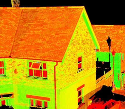
If you have never encountered 3D scanning before, the easiest way to picture a point cloud is as a 3D digital connect the dots puzzle, but on a massive scale. Instead of a few dozen dots on a page, a point cloud consists of millions (sometimes billions) of tiny digital dots floating in a 3D space on a computer screen. Together, these dots form a pixel-perfect digital model of your site.
- The Scan: My laser scanner spins around scanning a room, shooting millions of invisible laser beams per second.
- The Bounce: The laser hits a surface (like a wall, beam, or pipe) and bounces back.
- The Dot: The scanner calculates the exact distance and drops a digital dot at that precise spot.
Why it matters: From a normal viewing distance, this massive cloud of dots looks like a highly detailed solid 3D photograph. Because every single dot knows its exact height, width, and depth, architects and engineers can use a virtual tape measure to check any distance or clearance down to the millimetre from their own computers.
My Key Applications
- Measured Building Surveys: Creating highly accurate floor plans, roof plans, sections and both internal and external elevations.
- Topographical Mapping: Mapping complex terrain, land contours and elevations safely and efficiently over large areas.
- Heritage Preservation: Digitally archiving historic buildings and delicate monuments without causing physical contact or damage.
Why Choose 3D Laser Scanning?
- Unmatched Accuracy: Minimises human error from your project data.
- Maximum Efficiency: Drastically reduces on site measuring time.
- Enhanced Safety: Safely captures data from hazardous, busy or hard to reach locations from a distance.
- Seamless Integration: I deliver data that integrates directly into standard CAD software (like AutoCAD) for immediate use by your design team.
Ready to stream-line your next project?
Contact me today to discuss your site requirements or to request a competitive quote.